It's so bad that we're a week into it and still really can't grasp what's happened.
As of now, nothing is final & everything could be reclassified. If it were a dozen tornadoes, sure we'd know what we're dealing with, but it's so widespread & so devastating that we just don't know. I'm clawing my way thru sister agencies to try and get aerial photographs of affected areas in the NW corner & it's impossible. I've got to do job loss & damage assessments & can't get my hands on the materials I need because those photographs might not even exist yet. Usually it's flown within a day of a disaster, it's now been a week, and what we're looking for still hasn't been covered. The reason a lot of these storms have fluctuated between EF3/EF4/EF5 status is because full assessments haven't been done yet.
I know the storm that started in Smithville is like nothing that's ever been seen before. There's a clear path of distruction from the MS state line to the TN state line. It's unbelievable.
Here's the storm rotation strength & path from last weeks outbreak:
http://www.norman.noaa.gov/wp-content/uploads/2011/04/April-27-Rotation-Tracks-Eastern-U.S..jpg
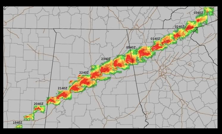
Notice how red it is over the Shoals area? The red & yellow represent the strongest winds. It could have been absolutely devastating if the storms that passed over us had touched down. We're extremely fortunate.
Just got an email showing that the system that started in Smithville was upgraded to be an EF5 for the duration of it's path.
Check this map out:
NWS
Zoom in on Hackleburg. 2 EF5's converged to create a dual vortex. I heard about this yesterday and was shocked.